
The problem:
Recently, we have seen a number of relatively high-profile aviation incidents caused by incorrect altimeter settings. Detecting, and ultimately preventing, these errors is a great application for Flight Data Monitoring or FOQA. Let’s see how…
In October 2021 there was a relatively serious incident involving a Bombardier CRJ100 in Lyon. In this case, the crew continued a visual approach to land without incident, but this could have been much more serious if the weather was poor.
Then in May 2022 a similar incident occurred. This time with an A320 inbound to Paris. Again, because of the extra safety guards we have in place, this flight landed without incident (although it did take a couple of approaches to land).
Although both of these flights landed without incident, the aviation industry is taking a proactive approach to reducing the risks associated with incorrect altimeter settings and ensuring that all are aware of the problem.
The problem is serious enough that EASA (the European Union Aviation Safety Agency) has raised awareness of this problem and has a very well written article describing it, published just this past August.
The EASA article mentions some ways in which Flight Data Monitoring can be used to help address this problem – some more complicated than others. Here, I would like to show you how we are working with some of our customers to help identify and address this problem.
Some background:
I realize that many of our readers are somewhat of “aviation hobbyists” and not necessarily aviation professionals so I am including a very brief explanation of how an altimeter works. If you are already familiar with the high-level workings of a pressure sensitive altimeter, feel free to skip this section…
The design of an altimeter has not changed much in the last few decades or so, and for good reason. It is a relatively simple and reliable design.
Basically, an altimeter contains a sealed chamber (think of a sealed balloon) within an instrument housing. The housing is vented to the atmosphere so as the pressure outside decreases (e.g. when we climb), the “balloon” expands. That expansion shows up as a needle or two that tell us what our altitude is.
As the pressure outside increases (e.g. when we descend), the balloon compresses and we see our altitude decrease.
It’s a time-proven design and, as I mentioned, it works quite well but it does have some limitations.
For one, the pressure around us increases and decreases quite regularly – whether we are climbing, descending, or standing with our feet firmly planted on the ground.
Consider, for example, we are sitting in our airplane at 1500 ft elevation above sea level. Let’s assume that our altimeter is set “perfectly” (more on that in a moment). Our altimeter would read 1500 ft (Note: NOT zero – pressure sensitive altimeters are meant to read altitude above sea level – not the ground).
Now imagine a low-pressure system moves in the next day. This is similar to climbing in an aircraft (pressure decreases as we climb and increases as we descend).
The altimeter has no idea WHY the pressure is lower – it just knows that it is, so it will read something more than 1500 ft, maybe 2000 ft. This is clearly wrong because we are still sitting in our airplane at the airport. We didn’t levitate 500 ft above the airport!
Now, if you think about this, this has the potential to be a very serious problem. In our example, we are just sitting in our plane at the airport, but imagine we were coming in to land in low visibility. If we didn’t correct our altimeter, we would touch down when it read 2000 ft – not 1500 ft. We would still think we had 500 ft to go at the point of touch down, assuming we are still conscious enough to think at that point.
To get around this problem, our altimeters have a little dial and window that allows us to set the altimeter so that it’s more aligned with the current atmospheric pressure. You can see the window just inside the image of altimeter at the top of the page (it’s at the 3 o’clock position and reads roughly 1016).
This will come from the weather office and will be available in weather reports and from Air Traffic Control (ATC). The pilot can then set the correct setting in the “window” by twisting a knob (located right by the “6” in the image at the top of the blog).
In our scenario then, before we go flying, we get the current altimeter setting, dial it up in our altimeter, and we should see that our altimeter reads 1500 ft – the elevation of the airport. That all looks good, so we go flying.
Hopefully you can see how having the incorrect altimeter setting can become a serious problem, but now you might be wondering why this can be a problem in the first place. You set it before you take off, see that the altitude matches that of your airport, then go flying, right?
Sort of, but not quite. The pressure changes constantly, so even if you go for a local flight around your airport, you will likely have to change the altimeter setting before you land.
On top of that, once a high-performance aircraft (like your typical transport aircraft) climbs above 18,000 ft, the pilots will set the altimeter to a standard setting (29.92 inches of mercury or 1013 millibars) so that everyone at those altitudes is at the same setting (at these altitudes we’re more concerned with separation between other aircraft than we are with running into the ground). Incidentally, we call that altitude “Pressure Altitude”.
Once those aircraft descend below 18,000 ft, the crew will get a new, local altimeter setting from ATC.
Even on a relatively short 2-to-3-hour flight, there can be a considerable difference in these settings. So, it’s important that these are accurately set.
Now, I don’t want this to make anyone fearful of flying. There are many other systems in place to prevent this being a deadly problem – we have Radar Altimeters (that measure actual altitude above ground at lower altitudes), Ground Proximity Warning Systems (GPWS) and ATC monitoring, like we saw in the two real-world examples referenced above.
In aviation, we like to think of the “Swiss cheese” safety model, so if we can minimise the risk of just one of the “holes” lining up, such as setting the altimeter incorrectly, it gets us one step closer to preventing a major accident.
Is this a frequent problem?
One interesting question in all of this is, “is this a frequent problem?”
I’m honestly not even sure that we know. One of the unfortunate things about aircraft accidents (in my opinion) is that, many times, we don’t realize how widespread a problem is until we have a major accident, and we complete a thorough investigation.
This is where Flight Data Monitoring or FOQA can really help us out. There are ways in which we can regularly monitor flight data to see if this is happening often and, if so, are there any patterns to where/when it is happening?
Once we can identify these patterns, we can take steps to reduce the chances of them turning into a bigger problem.
How can Flight Data Monitoring Help?
So, how can we use Flight Data Monitoring to help catch these potential issues.
As noted in the EASA article, there are a number of ways Flight Data Monitoring can be utilized to identify and reduce the risk of incorrect altimeter settings. Some are more complicated than others, but I’ve always liked the saying, attributed to Einstein, “Everything should be made as simple as possible, but no simpler.”
With that in mind, we have a couple of relatively simple options. Altimeter setting is recorded on most modern aircraft so we can monitor it in some way.
Where multiple altimeter settings are recorded (e.g. pilot and co-pilot), we can monitor for different settings and create a Flight Data Monitoring event if the two disagree by some value.
My opinion is that there is little benefit in this one. I would expect the crew to identify and correct an altitude mis-compare long before this becomes a serious problem. But, this should be a very simple event to monitor as part of your Flight Data Monitoring program, so it certainly does not hurt to add it.
What is more likely, though, is that both pilots would have the incorrect altimeter setting so we need to dig a little deeper.
Currently, we are working with our customers to use the altimeter setting from the METAR for the arrival airport (for the hobbyists, the METAR is the local weather report for an airport, normally issued once an hour but sometimes more frequently during periods of rapidly changing weather conditions).
With this information, we can read the altimeter setting set by the crew and compare it to the altimeter setting reported in the METAR. We can then raise any events where there is a significant discrepancy or difference between the reported altimeter setting and what the crew actually have set in the aircraft.
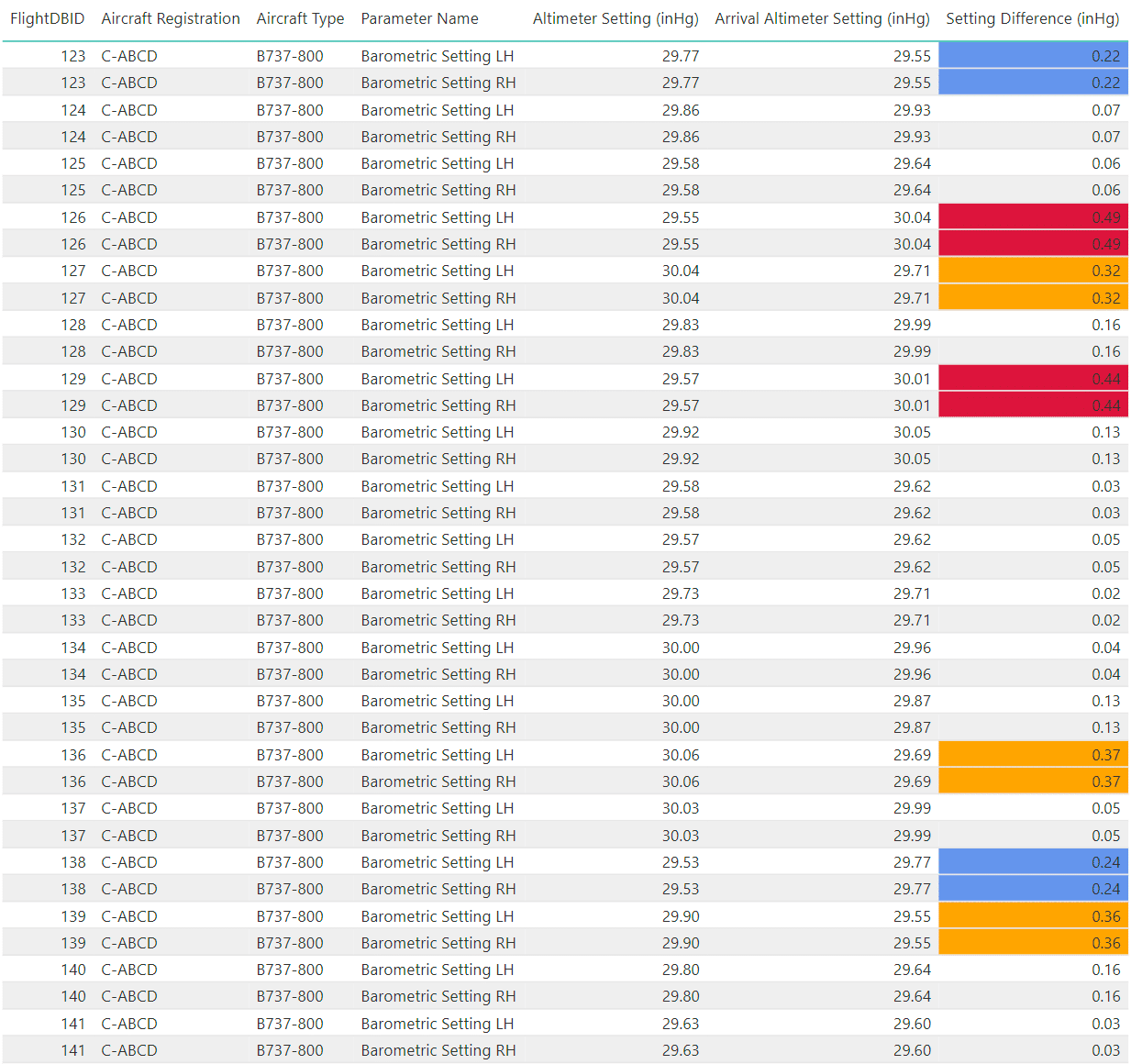
Below is a sample report of how we can detect these types of events. We can capture aircraft and arrival information so that we can try to identify any patterns or trends of where and when this is happening.
Note that in the screenshot below, these numbers are completely fictional. In reality, we do not see this type of event very often in our data, which is not surprising given our customers’ proactive approach to flight safety.
Some Tips
If you do decide to use the altimeter setting from the weather reports, I would suggest not making your limits too restrictive or “tight”.
There are limitations with using the METAR data. It can be up to 30 minutes old and it is not necessarily the same value that ATC reported to the flight crew during arrival. If you set your trigger values to low, you could get bombarded with a large number of false, non-events simply because of the slight differences that are to be expected.
It should be pretty close, though and we really are more interested in detecting significant variations, so set your trigger limits accordingly.
Once you have your Flight Data Monitoring program set up, see if any patterns are developing. This will likely take a few months of data collection as it is likely that this event will not be detected very often.
Having said that, if you do pick up a significant variation, investigate it promptly and appropriately. If possible, it could be worthwhile getting information from the flight crew. There are things that the data can’t show such as the workload in the flight deck at the time. Flight crew interviews are invaluable in cases like this.
Otherwise, be patient and review how your data is trending over time. If you are noticing a number of these types of events, see if there are any patterns. Ask yourself questions such as:
- Is this happening only at certain airports?
- Is it mostly happening at certain times of day?
- Is it mainly in IMC or VMC?
- Is it specific to a certain aircraft type?
Once you can answer these types of questions, you can take steps to identify and address the root cause.
Summary
Although there are some limits to what is possible with Flight Data Monitoring, we certainly can effectively monitor for incorrect altimeter settings. In fact, it is relatively straight forward to do with very little complexity.
By working with your Flight Data Monitoring service or software provider, they should be able to help you get this new event set up with minimal effort so that you can catch these potential errors before they become more serious problems.
And as always, if you need any assistance setting up your program, you can always reach out to us at info@scaledanalytics.com, fill out our contact form, or you can leave a comment below and someone from our team will be happy to help as best they can.
Fly safe!

Let’s keep in touch
Sign up to get notified of new blog posts, videos or other news and information related to flight data.

